Storms or sun? Weather predictions for this and next week in france
- Select a language for the TTS:
- UK English Female
- UK English Male
- US English Female
- US English Male
- Australian Female
- Australian Male
- Language selected: (auto detect) - EN
Play all audios:

JUNE 1 WAS THE COLDEST DAY OF JUNE SINCE 2016 BUT TEMPERATURES ARE EXPECTED TO RETURN, AND POTENTIALLY SURPASS, USUAL LEVELS SOON DO YOU RECEIVE THE CONNEXION'S FREE WEEKDAY NEWSLETTER?
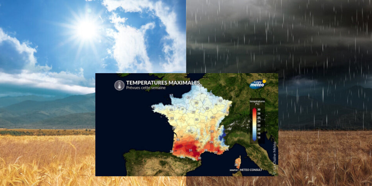
Sign up here The weather will continue to be unstable in France throughout the first two weeks of June, with periods of summer heat and sun interspersed with rain and storms after a month
of May with heavy rain. People living in the south can expect hot weather and sun towards the end of this week, with temperatures reaching around 30C. In the northern half of the country,
temperatures will be between around 18C and 24C. However, this is not set to last, with rainstorms expected the following week due to high pressure and cyclonic weather in the Atlantic
Ocean as the season of heavy rain continues. > 🌡️🥶 Voici, pour l'ensemble de cette semaine, les > #températures maximales possibles dans chaque région. Le contraste > est bien
présent entre la #chaleur qui va remonter sur le sud-ouest > et la #fraîcheur qui va se maintenir près des côtes de la Manche. > #météo pic.twitter.com/xpWysFjkH1 > — La Chaîne
Météo (@lachainemeteo) June 3, 2024 SUMMER WEATHER SETTING IN THIS WEEK June 1 was the coldest day of June since 2016 but temperatures are expected to return, and potentially surpass, usual
levels this week. From Monday (June 3) to Wednesday, the sky will be mostly clear, except in some areas of the Pyrenees and the Alps and in the north, which are likely to have some light
rain. Thursday is expected to be the sunniest day across France, with temperatures reaching 30C in the south and good weather, even if a little colder, predicted for the rest of the
country. This is due to an anticyclone (area of high pressure) moving over the south as fresh air from the polar region will move over the north, particularly Brittany. > 🌡️ Cette
semaine, l'été et la #chaleur vont s'installer sur > le sud de la France en raison de l'arrivée d'une masse d'air > tropicale. Le nord du pays restera en
bordure d'air polaire avec une > #fraîcheur persistante de la Bretagne à la frontière belge. > pic.twitter.com/8pUyaEmotS > — La Chaîne Météo (@lachainemeteo) June 2, 2024
There will be some rain in the centre of France on Friday but the rest of the country is set to have fairly high temperatures, as well as sunny and cloudy spells. At the weekend, the
anticyclone (area of high pressure) that will warm up France will move towards central Europe and is expected to give way to stormy weather and rain. Read more: Lightning kills football
coach during training session in north France ALTERNATING GOOD AND BAD WEATHER The weather is set to be unstable and unpredictable the following week. It is likely that hot, sunny summer
days will alternate with storms and rainy spells and both the weather conditions and temperatures are likely to yo-yo significantly. The French state weather service, Météo France, has
predicted a hotter summer than average. It has also said it expects the weather to be drier but that it is still too early to be precise. Read also: May 2024 MAP: Where are water
restrictions in place in France?