Interferometric radar measurements of water level changes on the Amazon flood plain
- Select a language for the TTS:
- UK English Female
- UK English Male
- US English Female
- US English Male
- Australian Female
- Australian Male
- Language selected: (auto detect) - EN
Play all audios:

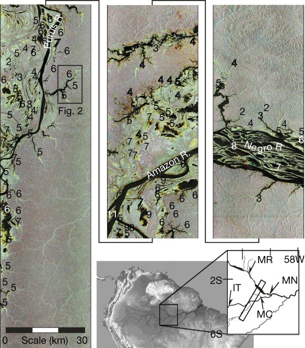
Measurements of water levels in the main channels of rivers, upland tributaries and floodplain lakes are necessary for understanding flooding hazards, methane production, sediment transport
and nutrient exchange. But most remote river basins have only a few gauging stations and these tend to be restricted to large river channels. Although radar remote sensing techniques using
interferometric phase measurements have the potential to greatly improve spatial sampling, the phase is temporally incoherent over open water and has therefore not been used to determine
water levels. Here we use interferometric synthetic aperture radar (SAR) data1,2,3, acquired over the central Amazon by the Space Shuttle imaging radar mission4, to measure subtle water
level changes in an area of flooded vegetation on the Amazon flood plain. The technique makes use of the fact that flooded forests and floodplain lakes with emergent shrubs permit radar
double-bounce returns from water and vegetation surfaces5,6, thus allowing coherence to be maintained. Our interferometric phase observations show decreases in water levels of 7–11 cm per
day for tributaries and lakes within ∼20 km of a main channel and 2–5 cm per day at distances of ∼80 km. Proximal floodplain observations are in close agreement with main-channel gauge
records, indicating a rapid response of the flood plain to decreases in river stage. With additional data from future satellite missions, the technique described here should provide direct
observations important for understanding flood dynamics and hydrologic exchange between rivers and flood plains.
We thank H. Zebker, C. Birkett and J. Ridley for comments on the manuscript. The Cornell Theory Center provided the computer resources necessary for SAR processing. Gamma Remote Sensing
Research and Consulting provided SAR technical advice. This work was supported by NASA.
Institute for Computational Earth System Science, University of California, Santa Barbara, 93106, California, USA
Douglas E. Alsdorf, John M. Melack, Leal A. K. Mertes & Laura L. Hess
Donald Bren School of Environmental Science and Management, University of California, Santa Barbara , 93106, California, USA
Department of Geography, University of California, Santa Barbara, California, 93106, USA
Department of Geography, University of California, Los Angeles, California, 90095 , USA
Anyone you share the following link with will be able to read this content: